


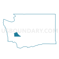
Tumwater 16 Voting District, Thurston County, Washington
About
Outline

Summary
| Unique Area Identifier | 689652 |
| Name | Tumwater 16 Voting District |
| County | Thurston County |
| State | Washington |
| Area (square miles) | 0.05 |
| Land Area (square miles) | 0.05 |
| Water Area (square miles) | 0.00 |
| % of Land Area | 100.00 |
| % of Water Area | 0.00 |
| Latitude of the Internal Point | 46.96310940 |
| Longtitude of the Internal Point | -122.89013170 |
Maps


Graphs
Select a template below for downloading or customizing gragh for Tumwater 16 Voting District, Thurston County, Washington


Neighbors
Neighoring Voting District (by Name) Neighboring Voting District on the Map
- Airport Voting District, Thurston County, WA
- Tumwater 23 Voting District, Thurston County, WA
- Tumwater 5 Voting District, Thurston County, WA